Daylighting the Saw Mill River
![]()
![]()
Efforts to bring back a natural Yonkers waterway are changing the city
It is not often that Yonkers can claim to be more innovative than New York City, but in its gritty downtown corridor, a unique project unlike anything in the five boroughs is currently unfolding.
Millions of dollars have been invested, dozens of buildings have been demolished, parking lots have been ripped up and removed from the center of town, and new habitats for muskrats, egrets, and American eels have been created. This is the daylighting of the Saw Mill River, one of the most daring river restoration projects on the East Coast.
As the last vestiges of the urban industrial waterfront are slowly erased from New York state’s post-industrial cities, many of its polluted rivers and waterways are finally being remediated and modernized, and in New York City, this has led to an impressive array of restoration projects. Wetlands are being replanted at Alley Creek, reforestation work is being completed along the Bronx River, Superfund cleanups have begun in the Newtown Creek and Gowanus Canal, marshes and parks are being created along the Harlem River, and new creeks are now being engineered in the Staten Island Bluebelt system. But the city has yet to daylight any of its buried rivers.
:format(webp)/cdn.vox-cdn.com/uploads/chorus_asset/file/7651493/02_kensinger_saw_mill_river_DSC_5414.jpg)
Daylighting is the practice of uncapping rivers that have been covered over by human development and returning them to some semblance of a natural waterway. Urban creeks have been daylighted in cities around the world, from the River Quaggy in London to the Cheonggyecheon Stream in Seoul. “There are rivers under every industrial city that exists, because when you build a city, people develop around a river,” says Caroline Bacle, the director of the 2012 documentary Lost Rivers, which examined several daylighting projects around the globe. “Now that a lot of industries are gone from cities, they have had to reinvent themselves,” she continues. “It’s near impossible to get rivers back to what they once were, so [daylighting is] having a new vision about rivers in the city.”
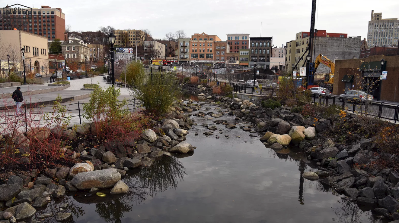
In Yonkers, the ongoing efforts to daylight the Saw Mill River have already radically altered the city’s physical landscape, and more change is still to come. The first major phase of this project was completed in 2012, opening up an airy new park in the heart of the city where a decades-old parking lot once stood. Flocks of ducks and schoolchildren now gather along the banks of this swiftly flowing stream, where hundreds of different species now live. “The Yonkers story is special, because it could have just been creating a fountain in the middle of a park,” says Bacle. “But it was about bringing back habitat for animals, which was incredible.”
This past summer, the latest phase of daylighting along the Saw Mill River was completed at the Mill Street Courtyard, an $8.3 million restoration project that has created a series of elevated walkways and small public plazas above the river, inside a city block that was once a weed-strewn empty lot. The project will soon expand into a fourth phase upriver, and this past week the city received a $2.5 million grant, which will help daylight a segment of the waterway buried underneath a desolate sea of concrete called Chicken Island.
:format(webp)/cdn.vox-cdn.com/uploads/chorus_asset/file/7651509/03_kensinger_saw_mill_river_DSC_5275.jpg)
New York City is definitely not Yonkers, and we probably won’t be tearing down buildings in Midtown anytime soon to unearth hidden rivers and create fish ladders. But the city does have several extensive buried waterways that could be brought back to the surface. The chief candidate among them is the lower section of Tibbetts Brook, which travels underground beneath the streets of the Bronx after flowing aboveground through Yonkers, just a mile away from the Saw Mill River.
Local parks and environmental groups are in agreement that Tibbetts Brook should be daylighted, and the NYC Parks Department has included the idea in their master plan for Van Cortlandt Park, suggesting that the brook be routed above ground to the Harlem River, after leaving Van Cortlandt Lake in the park. “Tibbetts Brook is really the lowest hanging fruit, for a few reasons, and the Parks Department has been looking at it more seriously over the last few years,” says Steve Duncan, a scholar of New York’s underground waterways who also appears in Lost Rivers. “Tibbetts Brook is far more feasible than anything else outside of Staten Island right now.”
And unlike the Saw Mill River project, daylighting Tibbetts Brook would also have a huge impact on the urban sewer system, according to Duncan. “The Saw Mill River in Yonkers is a daylighting project where we made this great environmental amenity, and it’s very educational and I think it’s awesome,” he explains, “but it doesn’t actually reduce combined sewer overflows in that area, because the Saw Mill River was never connected to the combined sewer system.” At Tibbetts Brook, Duncan believes that New York City can create an even more innovative daylighting project by separating the freshwater flow of the brook from the city’s antiquated sewer system. “We have a chance for something that really takes it to a higher level in New York.”
:format(webp)/cdn.vox-cdn.com/uploads/chorus_asset/file/7651515/04_kensinger_saw_mill_river_DSC_5263.jpg)
Although daylighting New York City’s underground rivers could help reduce the massive amounts of rain and freshwater that currently flow into the sewage system, finding a way to separate out household waste from underground creeks is something that has so far been prohibitively expensive. “It’s hard to daylight. It’s very expensive to daylight,” says Bacle. “It’s difficult in a big city, because a lot of the sewers are combined. I think the key is thinking organically about all these different elements, and that’s what makes the best projects. But it’s all a question of money as well.” For now, a walk up the Saw Mill River and down Tibbetts Brook offers up a fascinating chance to consider the future possibilities for New York’s historic rivers.
:format(webp)/cdn.vox-cdn.com/uploads/chorus_asset/file/7651519/05_kensinger_saw_mill_river_DSC_5417.jpg)
In downtown Yonkers, signage explains how the Saw Mill River was routed underground almost 100 years ago and covered over by a parking lot. “Everybody thought this was a lousy, stinky little river. So they put this cap on top of it in the 1920s,” according to an interview from Lost Rivers with Anne-Marie Mitroff of Groundwork Hudson Valley. “It was buried and we put a parking lot on it. We really mucked around with this city.”
:format(webp)/cdn.vox-cdn.com/uploads/chorus_asset/file/7651521/06_kensinger_saw_mill_river_DSC_5407.jpg)
This section of the Saw Mill River was daylighted in 2011, when its waters first flowed into a newly made riverbed. “We built a totally new river,” says Mitroff in the film. “It actually is a living river. It has living things in it, and they seem to be thriving.”
:format(webp)/cdn.vox-cdn.com/uploads/chorus_asset/file/7651529/07_kensinger_saw_mill_river_DSC_5349.jpg)
The industrial history of the Saw Mill River dates back to Adriaen van der Donck, a famed Dutch colonist, who built the first mill in the area at this site in the 1650s. The river still flows past Philipse Manor Hall, the former residence of a mill owner that dates back to 1682.
:format(webp)/cdn.vox-cdn.com/uploads/chorus_asset/file/7651593/08_kensinger_saw_mill_river_DSC_5325.jpg)
Today, this new section of the Saw Mill River flows through a public park with an outdoor classroom and stage, before passing underneath the Yonkers train station and emptying out into the Hudson River.
:format(webp)/cdn.vox-cdn.com/uploads/chorus_asset/file/7651601/09_kensinger_saw_mill_river_DSC_5249.jpg)
A fish ladder and an eel ladder have been built, allowing migrating species to travel upriver. The river is now home to hundreds of different species, including snapping turtles, egrets, and salamanders. “People are coming back to living in cities, and want to be closer to nature,” says Bacle. “It’s bringing back nature in the city so it’s a better place to live.”
:format(webp)/cdn.vox-cdn.com/uploads/chorus_asset/file/7651607/10_kensinger_saw_mill_river_DSC_5398.jpg)
Despite the city’s hopes that the daylighting project would rejuvenate the area, many of the older storefronts in downtown Yonkers remain vacant and boarded up. “It was a big manufacturing city, and now what is it? What fills the void? How do you bring people back, and reinvent it as a space where people want to live?” says Bacle.
:format(webp)/cdn.vox-cdn.com/uploads/chorus_asset/file/7651631/11_kensinger_saw_mill_river_DSC_5332.jpg)
A large section of historic buildings along the southern bank of the river is now being demolished, to make way for a 442-unit housing complex. “The project includes two 25- and 17-foot towers plus a 539-space parking garage,” according to the Journal News.
:format(webp)/cdn.vox-cdn.com/uploads/chorus_asset/file/7651635/12_kensinger_saw_mill_river_DSC_5444.jpg)
Upstream, at the Mill Creek Courtyard, phase three of the Saw Mill River daylighting has now been completed, opening up the interior of a downtown block.
:format(webp)/cdn.vox-cdn.com/uploads/chorus_asset/file/7651637/13_kensinger_saw_mill_river_DSC_5454.jpg)
An elevated walkway brings visitors into a mid-block courtyard, while passing above the previously hidden river.
:format(webp)/cdn.vox-cdn.com/uploads/chorus_asset/file/7651659/14_kensinger_saw_mill_river_DSC_5504.jpg)
Under the walkway, the river flows underneath two older warehouses, and past a small subterranean plaza planted with trees and shrubs.
:format(webp)/cdn.vox-cdn.com/uploads/chorus_asset/file/7651663/15_kensinger_saw_mill_river_DSC_5583.jpg)
Further into the new park, the river travels underneath a second walkway, where the sound of flowing water blocks out the nearby traffic of downtown Yonkers. The project here is modeled on “a type of vehicular-pedestrian street found in the Netherlands called a woonerf,” according to the Journal News.
:format(webp)/cdn.vox-cdn.com/uploads/chorus_asset/file/7651667/16_kensinger_saw_mill_river_DSC_5532.jpg)
A small amphitheater and a large mural have been completed here, providing a quiet respite in the center of town.
:format(webp)/cdn.vox-cdn.com/uploads/chorus_asset/file/7651669/17_kensinger_saw_mill_river_DSC_5524.jpg)
With three entry points, the central plaza of the Mill Creek Courtyard is now a busy interchange for pedestrians, joggers, and delivery trucks. Again, though, boarded up and empty buildings are a constant presence at the edge of the river.
:format(webp)/cdn.vox-cdn.com/uploads/chorus_asset/file/7651679/18_kensinger_saw_mill_river_DSC_5641.jpg)
Further up the river, Phase Two of daylighting helped create a park and overlook along this short segment, where a strip of buildings was demolished on the opposite banks to open up views of the river.
:format(webp)/cdn.vox-cdn.com/uploads/chorus_asset/file/7651681/19_kensinger_saw_mill_river_DSC_5654.jpg)
This is one of the few places in Yonkers where the waters of the Saw Mill River are easily accessible. From here, they flow underground, and then into Phase Three and Phase One, where the water is largely blocked off by railings and walls.
:format(webp)/cdn.vox-cdn.com/uploads/chorus_asset/file/7651683/20_kensinger_saw_mill_river_DSC_5677.jpg)
Upstream, the river goes underground once again, beneath the parking lot of Chicken Island. Phase Four of the daylighting process is scheduled to bring the river back into view here.
:format(webp)/cdn.vox-cdn.com/uploads/chorus_asset/file/7651687/21_kensinger_saw_mill_river_DSC_5724.jpg)
The river emerges once again beyond Chicken Island, flowing uncovered through much of Yonkers, although its waters are largely inaccessible and impassable, hidden behind warehouses and fences and blocked off by rocks and fallen trees.
:format(webp)/cdn.vox-cdn.com/uploads/chorus_asset/file/7651695/22_kensinger_saw_mill_river_DSC_5803.jpg)
Near Walsh Road and Nepperhan Avenue, the river flows through a graffiti-covered underpass, one of the only other areas where the water is easily accessed. Nepperhan was the original Native American name for the Saw Mill River.
:format(webp)/cdn.vox-cdn.com/uploads/chorus_asset/file/7651697/23_kensinger_saw_mill_river_DSC_5904.jpg)
From here, the Saw Mill River continues upstream for another 20 miles, running for much of its length alongside the Saw Mill River Parkway. Just a mile from here is Tibbetts Brook Park, where the waters of Tibbetts Brook flow downstream from a manmade pond.
:format(webp)/cdn.vox-cdn.com/uploads/chorus_asset/file/7651699/24_kensinger_tibbets_brook_DSC_6313.jpg)
Tibbetts Brook also flows next to the Saw Mill River Parkway in Yonkers, before entering the Bronx. From the constant traffic above, few drivers can see down into the sunken waterway.
:format(webp)/cdn.vox-cdn.com/uploads/chorus_asset/file/7651703/25_kensinger_tibbets_brook_DSC_6235.jpg)
The brook flows south into the overgrown wetlands of Van Cortlandt Park, where it crosses under the Henry Hudson Parkway. Tibbetts Brook was once called Moshulu by the Lenape Native Americans, a name now given to yet another parkway.
:format(webp)/cdn.vox-cdn.com/uploads/chorus_asset/file/7651711/26_kensinger_tibbets_brook_DSC_6192.jpg)
In Van Cortlandt Park, branches of Tibbetts Brook are rerouted around a public golf course and travel underneath various overpasses. This waterway helps drain a watershed of approximately 850 acres.
:format(webp)/cdn.vox-cdn.com/uploads/chorus_asset/file/7651715/27_kensinger_tibbets_brook_DSC_6151.jpg)
This shallow branch of the brook is a barrier to keep the public away from the golf course’s fairway. The river and golf course are also blocked off by a series of chain link fences.
:format(webp)/cdn.vox-cdn.com/uploads/chorus_asset/file/7651719/28_kensinger_tibbets_brook_DSC_6130.jpg)
Access to the brook throughout the park has been closed off by the golf course, which has even cut bridges in half, to give better access to golf carts.
:format(webp)/cdn.vox-cdn.com/uploads/chorus_asset/file/7651727/29_kensinger_tibbets_brook_DSC_6128.jpg)
The brook continues its manmade route down into Van Cortlandt Lake, and is home to a wide variety of animals, include coyotes, herons, owls, woodpeckers, rabbits, raccoons, muskrats, and skunks, according to the Parks Department.
:format(webp)/cdn.vox-cdn.com/uploads/chorus_asset/file/7651729/30_kensinger_tibbets_brook_DSC_6029.jpg)
At the end of the lake, Tibbetts Brook is routed underground, and into the sewer system. “That’s a case where you can say this water is not part of the city’s wastewater system up until this point, and daylighting would keep it from ever being part of that system,” says Steve Duncan.
:format(webp)/cdn.vox-cdn.com/uploads/chorus_asset/file/7651737/31_kensinger_tibbets_brook_DSC_6045.jpg)
Despite every effort to control its flow, a final section of water floods out from a marshland in Van Cortlandt Park, covering pathways and a barbecue area. From here, Duncan envisions the stream running down the center of Broadway and out to the Harlem River.
:format(webp)/cdn.vox-cdn.com/uploads/chorus_asset/file/7651741/32_kensinger_tibbets_brook_DSC_6052.jpg)
A car stuck in the marshy flood. “Daylighting doesn’t have to be an all or nothing proposition,” says Duncan. “What I think is really the key part about it is exposing more of the city’s workings to more people.”
Nathan Kensinger is a photographer, filmmaker, and curator who has been documenting New York City’s abandoned edges, endangered neighborhoods, and post-industrial waterfront for more than a decade. His Camera Obscura photo essays have appeared on Curbed since 2012. “Industrial Twilight,” an exhibit of Kensinger’s photographs of Brooklyn’s changing waterfront, is currently being exhibited at the Atlantic Avenue subway station in Brooklyn.